HiWATER: The multi-scale observation experiment on evapotranspiration over heterogeneous land surfaces (MUSOEXE-12)-dataset of flux observation matrix (thermal dissipation sap flow velocity Probe) from Jun to Sep, 2012

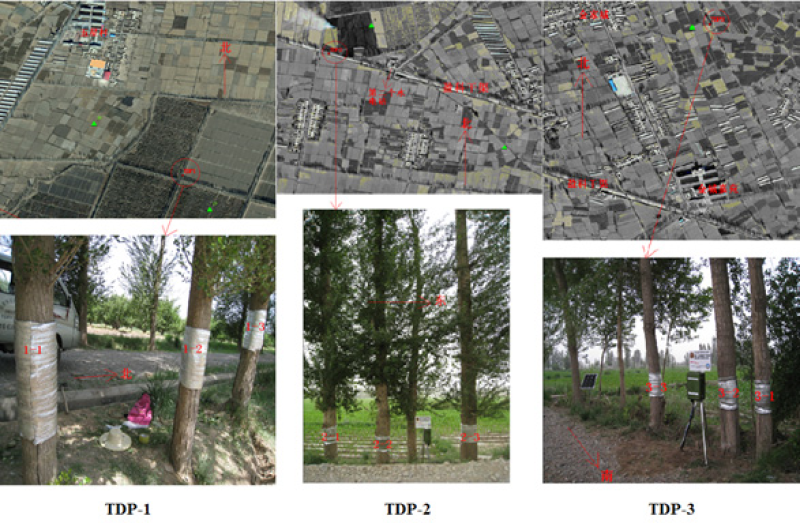
This dataset includes observational data of sap flow from 14 June to 21 September, 2012. The study area was located in the irrigation area within the middle reaches of the Heihe River Basin, China. Sample trees were selected for installing TDP (thermal dissipation sap flow velocity probe) instruments according to their height and diameter at breast height (DBH); only Popolusgansuensis trees were selected in this study. The TDP instrument is made in China; the model type was TDP30. There were 3 TDP observation sites, i.e., TDP-1, TDP-2 and TDP-3, which were located near the LAS4_S, EC6 and EC8 sites, respectively. The order of tree heights was TDP-2 > TDP-1 > TDP-3, and the order of DBH was TDP-2 > TDP-3 > TDP-1. At each site, 3 representative trees were selected to measure the sap flow. Three TDPs were mounted on the stem of each tree, one each for the southeast, southwest and north directions; the mounting height is 1.3 meters.
Each TDP had two probes. The raw TDP data included the temperature difference between the two probes at a frequency of 30 s. The released data include the 10 minute-averaged sap flow rate (cm/h), sap flow flux (cm^3/h), and daily transpiration (mm/d). The sap flow rate and the sap flow flux were calculated according to the temperature difference between the two probes; the shelter-forest transpiration per unit area (Q) was calculated based on the area of shelterbelts and density of Popolusgansuensis trees at each site. The data preprocessing steps included the following. (1) Unphysical data were excluded. (2) Missing data were filled with -6999. (3) Suspicious data, which were most likely caused by probe failure, were marked in red; confirmed bad data were excluded.
For more information, please refer to Liu et al. (2016) (for multi-scale observation experiment or sites information), Qiao et al. (2015) (for data processing) in the Citation section.
Data Citations
Related Literatures:1. Li, X., Liu, S.M., Xiao, Q., Ma, M.G., Jin, R., Che, T., Wang, W.Z., Hu, X.L., Xu, Z.W., Wen, J.G., Wang, L.X. (2017). A multiscale dataset for understanding complex eco-hydrological processes in a heterogeneous oasis system. Scientific Data, 4, 170083. doi:10.1038/sdata.2017.83.(View Details |Download )
2. Su, P.X., Yan, Q.D., Xie, T.T., Zhou,Z.J., & Gao, S. (2012). Associated growth of C3 and C4 desert plants helps the C3 species at the cost of the C4 species. Acta Physiologiae Plantarum, 34(6), 2057-2068.(View Details)
Cite as:Liu, S., Li, X. (2016). < b>HiWATER: The multi-scale observation experiment on evapotranspiration over heterogeneous land surfaces (MUSOEXE-12)-dataset of flux observation matrix (thermal dissipation sap flow velocity Probe) from Jun to Sep, 2012</b>2016. doi: 10.3972/hiwater.106.2013.db. (Download the reference: RIS | Bibtex )
Using this data, the data citation is required to be referenced and the related literatures are suggested to be cited.
References literature
1.Liu, S.M., Xu, Z.W., Song, L.S., Zhao, Q.Y., Ge, Y., Xu, T.R., Ma, Y.F., Zhu, Z.L., Jia, Z.Z., &Zhang, F. (2016). Upscaling evapotranspiration measurements from multi-site to the satellite pixel scale over heterogeneous land surfaces. Agricultural and Forest Meteorology, 230-231, 97-113. (View Details |Download)
2.Xu, Z.W., Ma, Y.F., Liu, S.M., Shi, S.J., &Wang, J.M. (2017). Assessment of the energy balance closure under advective conditions and its impact using remote sensing data. Journal of Applied Meteorology and Climatology, 56, 127-140. (View Details |Download)
3.Li Xin, Liu Shaomin, Ma Mingguo, Xiao Qing, Liu Qinhuo, Jin Rui, Che Tao. HiWATER: An Integrated Remote Sensing Experiment on Hydrological and Ecological Processes in the Heihe River Basin. Advances in Earth Science, 2012, 27(5): 481-498. (View Details |Download)
4.Li X, Cheng GD, Liu SM, Xiao Q, Ma MG, Jin R, Che T, Liu QH, Wang WZ, Qi Y, Wen JG, Li HY, Zhu GF, Guo JW, Ran YH, Wang SG, Zhu ZL, Zhou J, Hu XL, Xu ZW. Heihe Watershed Allied Telemetry Experimental Research (HiWATER): Scientific objectives and experimental design. Bulletin of the American Meteorological Society, 2013, 94(8): 1145-1160, 10.1175/BAMS-D-12-00154.1. (View Details )
Terms of Use
To respect the intellectual property rights, protect the rights of data authors, expand services of the data center, and evaluate the application potential of data, data users should clearly indicate the source of the data and the author of the data in the research results generated by using the data (including published papers, articles, data products, and unpublished research reports, data products and other results). For re-posting (second or multiple releases) data, the author must also indicate the source of the original data.
Support Program
National Natural Science Foundation of China
Related Resources
Comments
Sign In to add comments
Keywords
- Discipline: 陆地表层
- Theme: 植被 冠层截留 蒸散发
- Places:
- Time: 2012-06-14 to 2012-09-21
Geographic coverage
| Spatial coverage |
East:100.3685 South:38.8468 |
West:100.3685 North:38.8468 |
|---|
Details
- Format: 文本
- File size: 5.28 MB
- Browse count:14817
- Temporal coverage:2012-06-28 To 2012-10-05
- Access: Offline
- Updated time:2021-04-19
Authors
Resource Provider: LIU Shaomin LI Xin

 Copyright ©right; 2017 - 中国科学院西北生态环境资源研究院 - 兰州数云软件科技有限公司提供技术支持