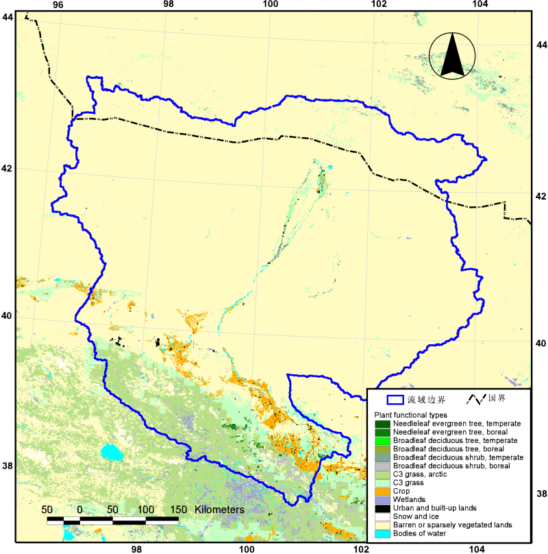
Plant functional types map in the Heihe River Basin (2000)

Vegetation functional type (PFT) is the combination of large plant species according to the ecosystem function of plant species and the way of resource utilization. Each plant functional type shares similar plant properties, which simplifies the diversity of plant species to the diversity of plant function and structure.Vegetation functional types have been used in the dynamic global vegetation model (DGVM) to predict changes in ecosystem structure and function under global change scenarios.The 1km vegetation functional pattern map of heihe basin is based on the 1km land cover map of heihe basin (MICLCover subset of heihe basin), and is divided by using the vegetation functional climate rules proposed by Bonan et al. (2002).The climate data utilize the 0.1 degree atmospheric drive data of he jie and Yang kun, developing China region from 1981 to 2008.This map can be used in the land surface process model of heihe river basin.
Copyright & License
File name: data is stored in text format, file name "heihe_pfts_2000.asc"</p><p>Data reading: ASCII files can be opened with a text program (such as notepad), if you want to use the graph, you can open with arcgi, reading process can generate GRID graphic data.
Data Citations
Related Literatures:1. Ran, Y. H. , Li, X. , Lu, L. , & Li, Z. Y. . (2012). Large-scale land cover mapping with the integration of multi-source information based on the dempster–shafer theory. International Journal of Geographical Information Science, 26(1), 169-191.(View Details)
Cite as:Ran, Y. (2013). < b>Plant functional types map in the Heihe River Basin (2000)</b>2013. doi: 10.3972/westdc.001.2013.db.heihe. (Download the reference: RIS | Bibtex )
Using this data, the data citation is required to be referenced and the related literatures are suggested to be cited.
Terms of Use
To respect the intellectual property rights, protect the rights of data authors, expand services of the data center, and evaluate the application potential of data, data users should clearly indicate the source of the data and the author of the data in the research results generated by using the data (including published papers, articles, data products, and unpublished research reports, data products and other results). For re-posting (second or multiple releases) data, the author must also indicate the source of the original data.
Support Program
Related Resources
1.The leaf water potential dataset in the downstream of the Heihe River Basin (2012)
2.Grassland interception dataset of Tianlaochi watershed in Qilian Mountain
3.Datasets for the SWAT model in Heihe Rriver Basin
7.Data of SPAC system in the lower reaches of Heihe River (2012-2013)
9.The data of desert plants photosynthetic organ traits (2011)
No record
No record
Comments
Sign In to add comments
Keywords
Geographic coverage
| Spatial coverage |
East:104.2 South:37.7 |
West:96.1 North:43.3 |
|---|
Details
- Temporal resolution: Monthly
- Spatial resolution: 1km - 10km
- Format: shp
- File size: 1.97 MB
- Browse count:11036
- Temporal coverage:2000-01-09 To 2001-01-08
- Access: Offline
- Updated time:2021-04-19
Authors
Resource Provider: RAN Youhua

 Copyright ©right; 2017 - 中国科学院西北生态环境资源研究院 - 兰州数云软件科技有限公司提供技术支持