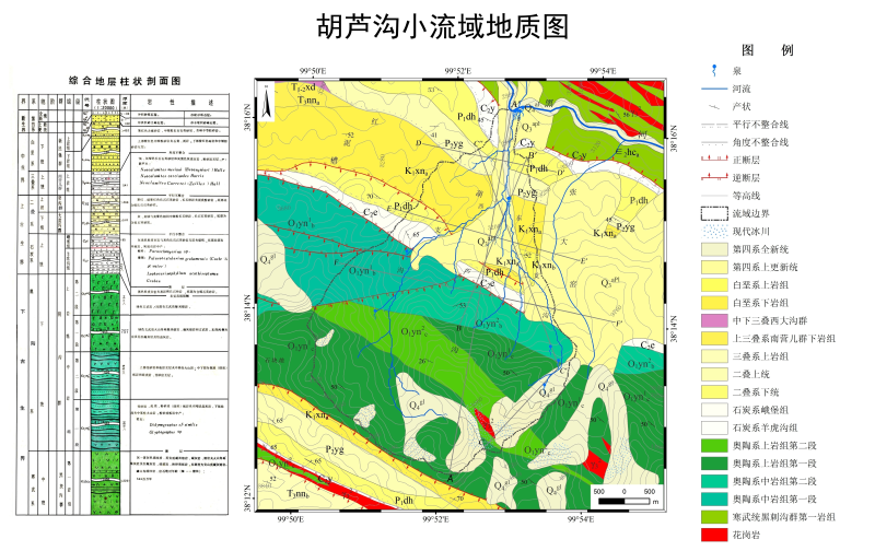
Geological map at 1:50000 of Hulugou catchment (2012)

Sketch map of 1:50000 geological map of hulugou small watershed in 2012, hulugou watershed is composed of Quaternary loose stratum and pre Cenozoic bedrock stratum. The pores of the bedrock stratum are mainly fissures and covered with thin residual slope deposits. The Pleistocene alluvial proluvial sand gravel layer (q3al + PL) above the piedmont plain is dominant. The loose formation in the front of the glacier is Holocene moraine gravel layer (q4gl), which is distributed under the modern cirque and forms lateral moraine and final moraine dike (ridge).
Copyright & License
Name of data file: Geological map.jpg; it can be opened and viewed by related image software.
Data Citations
Cite as:Sun, Z., Chang, Q. (2014). < b>Geological map at 1:50000 of Hulugou catchment (2012)</b>2014. doi: 10.3972/heihe.102.2014.db. (Download the reference: RIS | Bibtex )
Using this data, the data citation is required to be referenced and the related literatures are suggested to be cited.
Terms of Use
To respect the intellectual property rights, protect the rights of data authors, expand services of the data center, and evaluate the application potential of data, data users should clearly indicate the source of the data and the author of the data in the research results generated by using the data (including published papers, articles, data products, and unpublished research reports, data products and other results). For re-posting (second or multiple releases) data, the author must also indicate the source of the original data.
Support Program
Exploring snowmelt runoff processes using isotopic and hydrochemical data in Heihe River headwater catchments
Related Resources
1.Physical and chemical index data of deep drilling strata in the middle reaches of Heihe River (2013)
2.The leaf water potential dataset in the downstream of the Heihe River Basin (2012)
3.HiWATER: the albedo in the middle reaches of the Heihe River Basin (Jun. 29, 2012)
4.HiWATER: Dataset of infrared temperature in Zhanye Airport desert
7.HiWATER: Airborne CCD image data in Hulugou Catchment
9.HiWATER: Airborne CCD image data in the Shenshawo desert area of the Heihe River Basin
No record
No record
Comments
Sign In to add comments
Keywords
Geographic coverage
| Spatial coverage |
East:99.91667 South:38.2 |
West:99.81667 North:38.28333 |
|---|
Details
- Format: jpg
- File size: 7.0 MB
- Browse count:9125
- Temporal coverage:2012-01-15 To 2013-01-14
- Access: Offline
- Updated time:2021-04-20
Authors
Resource Provider: SUN Ziyong CHANG Qixin

 Copyright ©right; 2017 - 中国科学院西北生态环境资源研究院 - 兰州数云软件科技有限公司提供技术支持