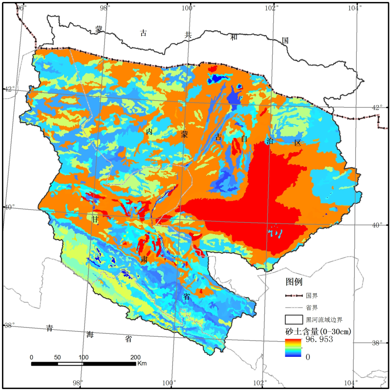
Grain size distribution of soil particles dataset of the Heihe basin

The source data of this data set comes from the 1:1 million soil map of China (Shi et al., 2004) and 8595 soil sections in the second Soil Census. The polygonal connection method is used to connect the soil profile with the soil map to obtain the soil sand, silt and clay content map. The distance between the profile and the map spot, the number of soil profiles and the information of soil classification are taken into account. Please refer to related papers and web pages for specific instructions.
Data characteristics
Projection: GCS_Krasovsky_1940
Coverage: Heihe River Basin
Resolution: 0.00833 degrees (about one kilometer)
Data format: FLT, tiff
Value range: 0% - 100%
Document description
Floating point grid files include:
Sand1.flt, clay1.flt - content of sand and clay in the surface layer (0-30cm).
Sand2.flt, clay2.flt - sand and clay content in the bottom layer (30-100cm).
Psd.hdr – header file:
Ncols - number of columns
Nrows - number of rows
Xllcorner - lower left latitude
Yllcorner - lower left longitude
Cellsize - cell size
NoData_Value – null
byteorder - LSBFIRST, Least Significant Bit First
TIFF grid files include:
Sand 1.tif, clay 1.tif - the content of sand and clay in the surface layer (0-30cm).
Sand 2.tif, clay 2.tif - sand and clay content in the bottom layer (30-100cm).
For data details, please refer to: http://globalchange.bnu.edu.cn/research/soil
Copyright & License
FLT, TIFF format storage
Data Citations
Cite as:Shangguan, W., Dai, Y. (2013). < b>Grain size distribution of soil particles dataset of the Heihe basin</b>2013. doi: 10.11888/Soil.tpdc.270589. (Download the reference: RIS | Bibtex )
Using this data, the data citation is required to be referenced and the related literatures are suggested to be cited.
References literature
1.FAO, IIASA, ISRIC, ISS-CAS, JRC, (2009). Harmonized World Soil Database (version1.1). FAO, Rome, Italy and IIASA, Laxenburg, Austia. (View Details )
2.Reynolds, C. A., Jackson, T. J., Rawls, W. J., (2000). Estimating soil water-holding capacities by linking the Food Agriculture Organization soil map of the world with global pedon databases, continuous pedotransfer functions. Water Resour. Res. 36, 3653-3662. (View Details )
Terms of Use
To respect the intellectual property rights, protect the rights of data authors, expand services of the data center, and evaluate the application potential of data, data users should clearly indicate the source of the data and the author of the data in the research results generated by using the data (including published papers, articles, data products, and unpublished research reports, data products and other results). For re-posting (second or multiple releases) data, the author must also indicate the source of the original data.
Support Program
国际科技合作与交流专项项目
Related Resources
Comments
Sign In to add comments
Keywords
- Discipline: Soil Science
- Theme: soil texture soil
- Places:
- Time: 2010
Geographic coverage
| Spatial coverage |
East:104.2 South:37.7 |
West:96.1 North:43.3 |
|---|
Details
- Format: 栅格
- File size: 23.74 MB
- Browse count:9932
- Temporal coverage:2018-11-27 To 2018-11-27
- Access: Offline
- Updated time:2021-04-18
Authors
Resource Provider: SHANGGUAN Wei DAI Yongjiu

 Copyright ©right; 2017 - 中国科学院西北生态环境资源研究院 - 兰州数云软件科技有限公司提供技术支持