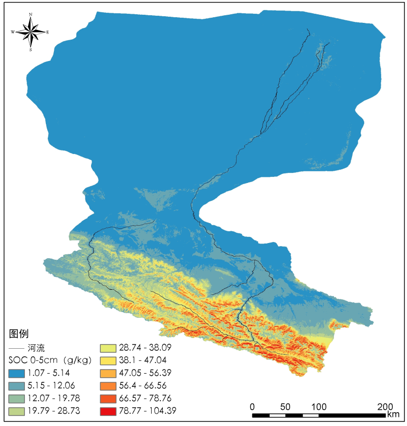
Digital soil mapping dataset of soil organic carbon content in the Heihe River Basin (2012)

According to the global soil map. Net standard, the 0-1m soil depth is divided into 5 layers: 0-5cm, 5-15cm, 15-30cm, 30-60cm and 60-100cm. According to the principle of soil landscape model, the spatial distribution data products of soil organic carbon content in different layers are produced by using the digital soil mapping method. The source data of this data set comes from the soil profile data integrated by the major research plan integration project of Heihe River Basin (soil data integration and soil information product generation of Heihe River Basin, 91325301).
Scope: Heihe River Basin;
Projection: WGS · 1984 · Albers;
Spatial resolution: 100M;
Data format: TIFF;
Dataset content:
hh_soc_layer1.tif: 0-5cm soil organic carbon content;
hh_soc_layer2.tif: 5-15cm soil organic carbon content;
hh_soc_layer3.tif: 15-30cm soil organic carbon content;
hh_soc_layer4.tif: 30-60cm soil organic carbon content;
hh_soc_layer5.tif: 60-100cm soil organic carbon content;
Copyright & License
. TIFF format storage
Data Citations
Related Literatures:1. Yang, R.M., Zhang, G.L, Liu, F., Lu, Y.Y., Yang, F., Yang, F., Yang, M., Zhao, Y.G., Li, D.C. (2016). Comparison of boosted regression tree and random forest models for mapping topsoil organic carbon concentration in an alpine ecosystem. Ecological Indicators, 60, 870–878.(View Details)
Cite as:Zhang, G. (2017). < b>Digital soil mapping dataset of soil organic carbon content in the Heihe River Basin (2012)</b>2017. doi: 10.3972/haihe.102.2017.db. (Download the reference: RIS | Bibtex )
Using this data, the data citation is required to be referenced and the related literatures are suggested to be cited.
Terms of Use
To respect the intellectual property rights, protect the rights of data authors, expand services of the data center, and evaluate the application potential of data, data users should clearly indicate the source of the data and the author of the data in the research results generated by using the data (including published papers, articles, data products, and unpublished research reports, data products and other results). For re-posting (second or multiple releases) data, the author must also indicate the source of the original data.
Related Resources
1.The leaf water potential dataset in the downstream of the Heihe River Basin (2012)
2.HiWATER: the albedo in the middle reaches of the Heihe River Basin (Jun. 29, 2012)
3.Datasets for the SWAT model in Heihe Rriver Basin
4.HiWATER: Dataset of infrared temperature in Zhanye Airport desert
No record
No record
Comments
Sign In to add comments
Keywords
Geographic coverage
| Spatial coverage |
East:101.9898 South:37.6893 |
West:97.0667 North:42.687 |
|---|
Details
- Format: 三维土壤有机碳含量分布数据集
- File size: 464.0 MB
- Browse count:10761
- Temporal coverage:2012-07-12 To 2015-07-12
- Access: Offline
- Updated time:2021-04-19
Authors
Resource Provider: 宋效东 ZHANG Ganlin

 Copyright ©right; 2017 - 中国科学院西北生态环境资源研究院 - 兰州数云软件科技有限公司提供技术支持