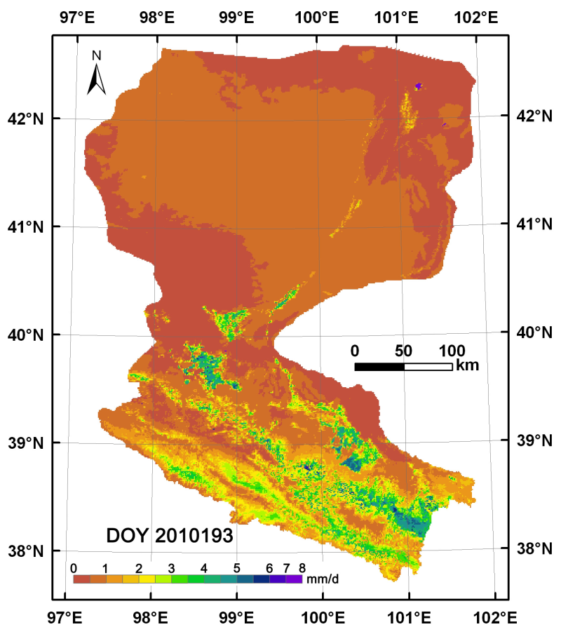
The evapotranspiration data in the Heihe River basin (2009-2011)

Near-surface atmospheric driving data prepared by ETMonitor and WRF models based on remote sensing surface evapotranspiration model were used to estimate the daily surface evapotranspiration of the heihe river basin at 1km from 2009 to 2011.The coordinate system is the longitude and latitude projection, and the spatial range is 96.5e -- 102.5e, 37.5n -- 43N.Using daily data storage, data format for GEOTIFF, naming: yyyyddd_EvapoTranspiration. tif, including yyyy for years, DDD for ordinal.The data type is single-precision floating point in mm/d and the invalid value is -9.
Copyright & License
File name: data stored in grid Geotiff format, the file name "yyyyddd_EvapoTranspiration. tif", including yyyy for years, ddd for ordinal. The data type is single-precision floating point in mm/d and the invalid value is -9.</p><p>Data reading method: Arcgis, Qgis and other software can be used to open and read.
Data Citations
Related Literatures:1. Cui, Y.K., and L. Jia.(2014). A Modified Gash Model for Estimating Rainfall Interception Loss of Forest Using Remote Sensing Observations at Regional Scale, Water, 6(4), 993–1012, doi:10.3390/w6040993.(View Details)
Cite as:Jia, L. (2015). < b>The evapotranspiration data in the Heihe River basin (2009-2011)</b>2015. doi: 10.3972/heihe.114.2013.db. (Download the reference: RIS | Bibtex )
Using this data, the data citation is required to be referenced and the related literatures are suggested to be cited.
References literature
1.Hu, G., Jia, L. (2015). Monitoring of evapotranspiration in a semi-arid inland river basin by combining microwave and optical remote sensing observations. Remote Sensing, 7(3), 3056-3087. (View Details )
2.Cui Y.K., Jia L., Hu G.C., Zhou J. (2015). Mapping of interception loss of vegetation in the Heihe River Basin of China using remote sensing observations. IEEE Geoscience and Remote Sensing Letters, 12(1), 23–27. (View Details |Download)
Terms of Use
To respect the intellectual property rights, protect the rights of data authors, expand services of the data center, and evaluate the application potential of data, data users should clearly indicate the source of the data and the author of the data in the research results generated by using the data (including published papers, articles, data products, and unpublished research reports, data products and other results). For re-posting (second or multiple releases) data, the author must also indicate the source of the original data.
Support Program
None
Related Resources
3.The leaf water potential dataset in the downstream of the Heihe River Basin (2012)
6.HiWATER: the albedo in the middle reaches of the Heihe River Basin (Jun. 29, 2012)
7.Grassland interception dataset of Tianlaochi watershed in Qilian Mountain
8.Datasets for the SWAT model in Heihe Rriver Basin
9.Thematic analysis data of Murray Darling basin Research in Australia (1912-2012)
No record
No record
Comments
Sign In to add comments
Keywords
Geographic coverage
| Spatial coverage |
East:102.5 South:37.5 |
West:96.5 North:43.0 |
|---|
Details
- Temporal resolution: Daily
- Spatial resolution: 100m - 1km
- Format: 栅格
- File size: 1350.0 MB
- Browse count:11599
- Temporal coverage:2009-01-16 To 2012-01-15
- Access: Offline
- Updated time:2021-04-19
Authors
Resource Provider: JIA Li

 Copyright ©right; 2017 - 中国科学院西北生态环境资源研究院 - 兰州数云软件科技有限公司提供技术支持