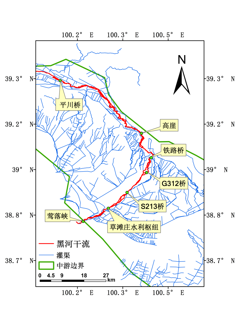
Dataset of estimation on channel section flow and stage in the midstream of the Heihe River Basin (1979-2014)

This data set consists of three parts: the first part is the monthly flow data of Yingluo gorge and caotanzhuang water conservancy project from 1979 to 2014; the second part is the S213 bridge (N38 ° 54'43.55 ", E100 ° 20'41.05") on the main stream of Heihe River from 1979 to 2014, G312 bridge (N38 ° 59'51.71 ", E100 ° 24'38.76"), railway bridge (n39 ° 2'33.08 ", E100 ° 25'49.42"), Gaoya bridge (n39 ° 08'06.35 ", E100 ° 25'58.23") and Pingchuan bridge (n39 ° The third part is the daily discharge and water level data of S213 bridge, G312 bridge, railway bridge, Gaoya bridge and Pingchuan bridge in the main stream of Heihe River from 1979 to 2014. Among them, the flow data refers to the section flow of Heihe River, and the water level data refers to the water level at the runoff densification observation point in the middle reaches of hiwater. The reliability of monthly data is higher than that of daily data, and the reliability of flow is higher than that of water level.
Data Citations
Related Literatures:1. Shuang Liu, Zhenghui Xie, and Yujin Zeng, (2016). “Discharge Estimation for an Ungauged Inland River in an Arid Area Related to Anthropogenic Activities: A Case Study of Heihe River Basin, Northwestern China,” Advances in Meteorology, vol. 2016, Article ID 6716501, 11 pages. doi:10.1155/2016/6716501(View Details)
2. Liu, S., Xie, Z.H., Zeng, Y.J. (2016). Estimation of streamflow in ungauged basins using a combined model of black-box model and semi-distributed model-taking Yingluoxia watershed as an example. Journal of Beijing Normal University (NATURAL SCIENCE EDITION), 052(3), 393-401.(View Details)
Cite as:Xie, Z. (2016). < b>Dataset of estimation on channel section flow and stage in the midstream of the Heihe River Basin (1979-2014)</b>2016. doi: 10.3972/heihe.0534.2015.db. (Download the reference: RIS | Bibtex )
Using this data, the data citation is required to be referenced and the related literatures are suggested to be cited.
References literature
1.Liu, S., Xie, Z., and Zeng, Y. (2016). Estimation of streamflow in ungauged basins using a combined model of black-box model and semi-distributed model: case study in the Yingluoxia watershed, Journal of Beijing Normal University. Natural Science, 52, 393-401. (View Details |Download)
Terms of Use
To respect the intellectual property rights, protect the rights of data authors, expand services of the data center, and evaluate the application potential of data, data users should clearly indicate the source of the data and the author of the data in the research results generated by using the data (including published papers, articles, data products, and unpublished research reports, data products and other results). For re-posting (second or multiple releases) data, the author must also indicate the source of the original data.
Support Program
None
Related Resources
2.Grassland interception dataset of Tianlaochi watershed in Qilian Mountain
3.Datasets for the SWAT model in Heihe Rriver Basin
4.Thematic analysis data of Murray Darling basin Research in Australia (1912-2012)
5.10 m meteorological gradient data set of hulugou basin (2012)
6.The monitoring data of the groundwater level in the middle of Heihe River basin (2005-2007)
7.Ground water level dataset in Hulugou sub-basin of Heihe River Basin (2011)
10.The canopy interception data of Qinghai spruce in Tianlaochi Catchment in Qilian Mountain
No record
No record
Comments
Sign In to add comments
Keywords
Geographic coverage
| Spatial coverage |
East:100.451 South:38.811 |
West:100.098 North:39.338 |
|---|
Details
- Format: EXCEL
- File size: 1.92 MB
- Browse count:9504
- Temporal coverage:1979-01-10 To 2015-01-09
- Access: Offline
- Updated time:2021-04-19
Authors
Resource Provider: XIE Zhenghui

 Copyright ©right; 2017 - 中国科学院西北生态环境资源研究院 - 兰州数云软件科技有限公司提供技术支持