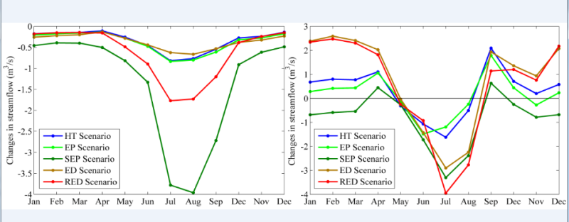
Simulations of SWAT model under multiple scenarios in the upper and middle reaches of the Heihe River Basin (2011-2030)

This data is SWAT scenario simulation data in the middle and upper reaches of Heihe River Basin. Scenarios include historical trend scenario (HT), ecological protection scenario (EP), strict ecological protection scenario (SEP), economic development scenario (ED) and rapid economic development scenario (red). Firstly, the dyna_clue model is used to simulate the land use change under different scenarios, and then the simulated land use map under different scenarios is imported into the SWAT model to simulate the daily and monthly runoff scenario data of the upstream outlet (Yingluo gorge) and the middle outlet (Zhengyi gorge) of the Heihe River Basin (assuming other conditions are the same). The period is 2011-2030. The data format is excel.
Copyright & License
Excel format storage
Data Citations
Cite as:Nan, Z., Zhang, L. (2015). < b>Simulations of SWAT model under multiple scenarios in the upper and middle reaches of the Heihe River Basin (2011-2030)</b>2015. doi: 10.3972/heihe.113.2014.db. (Download the reference: RIS | Bibtex )
Using this data, the data citation is required to be referenced and the related literatures are suggested to be cited.
Terms of Use
To respect the intellectual property rights, protect the rights of data authors, expand services of the data center, and evaluate the application potential of data, data users should clearly indicate the source of the data and the author of the data in the research results generated by using the data (including published papers, articles, data products, and unpublished research reports, data products and other results). For re-posting (second or multiple releases) data, the author must also indicate the source of the original data.
Support Program
None
Related Resources
1.Scenario analysis of social and economic development over Heihe River Basin (2020 & 2030)
3.HiWATER: the albedo in the middle reaches of the Heihe River Basin (Jun. 29, 2012)
4.Grassland interception dataset of Tianlaochi watershed in Qilian Mountain
5.Datasets for the SWAT model in Heihe Rriver Basin
6.Thematic analysis data of Murray Darling basin Research in Australia (1912-2012)
7.10 m meteorological gradient data set of hulugou basin (2012)
8.A survey construction of a water-saving society in Zhangye city, Gansu (2013)
9.The monitoring data of the groundwater level in the middle of Heihe River basin (2005-2007)
10.Input output table of Heihe River Basin in Gansu Province in 2002 and 2007
No record
No record
Comments
Sign In to add comments
Keywords
Geographic coverage
| Spatial coverage |
East:101.83 South:37.72 |
West:98.51 North:39.85 |
|---|
Details
- Format: EXCEL
- File size: 0.7 MB
- Browse count:9950
- Temporal coverage:2011-01-14 To 2031-01-13
- Access: Offline
- Updated time:2021-04-19
Authors
Resource Provider: NAN Zhuotong ZHANG Ling

 Copyright ©right; 2017 - 中国科学院西北生态环境资源研究院 - 兰州数云软件科技有限公司提供技术支持