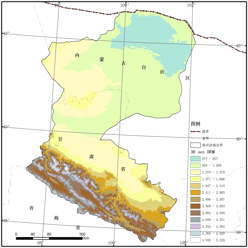
30 arc-second DEM data of the Heihe River Basin (2009)

This data is based on the DEM data generated by 1:250,000 digital contour lines and elevation points in China released by national basic geographic information center, and the DEM data set of heihe river basin is generated by the nearest neighbor method resampling method of ARCGIS spatial analysis module with a spatial resolution of 30 SEC.
Copyright & License
File name: the data is stored in GRID format. The files are divided into Albers and geographic folders. The file names are "dem30secalb" and "dem30secgeo".</p><p>Data reading: Arcgis, Qgis and other remote sensing software can be used to open the reading, in the form of images.
Data Citations
Cite as:National Basic Geographic Information Center. (2015). < b>30 arc-second DEM data of the Heihe River Basin (2009)</b>2015. (Download the reference: RIS | Bibtex )
Using this data, the data citation is required to be referenced and the related literatures are suggested to be cited.
References literature
1.Li Xin, Cheng Guodong, Wu Lizong. Digital Heihe River Basin. 1 : An Information Infrastructure for the Watershed Science. Advances in Earth Science, 2010, 25(3): 297-305. (View Details )
2.LI Xin, WU Lizong, MA Mingguo, GE Yingchun, RAN Youhua, WANG Liangxu, NAN Zhuotong ( Cold and Arid Regions Environmental and Engineering Research Institute, Chinese Academy of Sciences, Lanzhou 730000, China) (View Details )
3.Li, X., Nan, Z.T., Cheng, G.D., Ding, Y.J., Wu, L.Z., Wang, L.X., Wang, J., Ran, Y.H., Li, H.X., Pan, X.D., & Zhu, Z.M. (2011). Toward an improved data stewardship and service for environmental and ecological science data in west China. International Journal of Digital Earth, 4(4): 347-359. DOI: 10.1080/17538947.2011.558123. (View Details |Download)
4.Li, Z. , Xu, Z. , Shao, Q. , & Yang, J. . (2009). Parameter estimation and uncertainty analysis of swat model in upper reaches of the heihe river basin. Hydrological Processes, 23(19), 2744-2753. (View Details )
Terms of Use
To respect the intellectual property rights, protect the rights of data authors, expand services of the data center, and evaluate the application potential of data, data users should clearly indicate the source of the data and the author of the data in the research results generated by using the data (including published papers, articles, data products, and unpublished research reports, data products and other results). For re-posting (second or multiple releases) data, the author must also indicate the source of the original data.
Support Program
Related Resources
1.Physical and chemical index data of deep drilling strata in the middle reaches of Heihe River (2013)
2.Datasets for the SWAT model in Heihe Rriver Basin
5.1:1,000,000 Geomrphological map of the Heihe River basin (2000)
6.SRTM DEM data of the Heihe River Basin (2000)
8.The population dataset of the Heihe River Basin (2000-2009)
No record
No record
Comments
Sign In to add comments
Keywords
Geographic coverage
| Spatial coverage |
East:104.2 South:37.7 |
West:96.1 North:43.3 |
|---|
Details
- Temporal resolution: Yearly
- Spatial resolution: <= 0.01º
- Format: shp
- File size: 0.75 MB
- Browse count:12099
- Temporal coverage:2009-01-15 To 2010-01-14
- Access: Offline
- Updated time:2022-03-29
Authors
Resource Provider: National Basic Geographic Information Center

 Copyright ©right; 2017 - 中国科学院西北生态环境资源研究院 - 兰州数云软件科技有限公司提供技术支持