Evaporation and precipitation data in Hulugou outlet in the upstream of the Heihe River (2012)

1. Data overview:
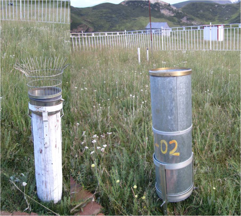
This data set is the scale artificial evaporation dish and precipitation data of qilian station from January 1, 2012 to December 31, 2012. The artificial evaporator is a 20cm standard evaporator, and the precipitation is a 20cm standard rain gauge.
2. Data content:
(1) the evaporation capacity is measured at 20:00 every day with 20 special measuring cups;It is before a day commonly 20 when measure clear water 20 millimeter with special measure cup (original quantity) pour into implement inside, 24 hours hind namely in the same day 20 hour, again measure the water inside implement (allowance), its reduce quantity is evaporation quantity.Namely: evaporation = original quantity - residual quantity.If there is precipitation between 20:00 of the previous day and 20:00 of the same day, the calculation formula is: evaporation = original quantity + precipitation - residual quantity.
(2) precipitation is generally observed in two stages, namely once at 8 o 'clock and once at 20 o 'clock each day. In the rainy season, observation periods are increased, and additional measurements are needed when the rainfall is large.The daily rainfall is divided into 8 a.m. of each day, and the precipitation from 8 a.m. to 8 a.m. of the next day is the precipitation of the current day.If it is rain, measure it with 20 special measuring cups. When it snows, only use the outer tube as snow bearing equipment, and then weigh it with an electronic balance (shenyang longteng es30k-12 type electronic balance, the minimum sensible amount is 0.2g).
3. Space and time range:
Geographical coordinates: longitude: 99° 53’e;Latitude: 38°16 'N;Height: 2981.0 m
Copyright & License
Data file name: hulugou basin 2012 artificial evaporating dish and precipitation data set.xlsx; WPS or excel and other software can be used for viewing and editing.
Data Citations
Related Literatures:1. Chen, R.S., Song, Y.X., Kang, E.S., Han, C.T., Liu, J.F., Yang, Y., Qing, W.W., &Liu, Z.W. (2014). A Cryosphere-Hydrology Observation System in a Small Alpine Watershed in the Qilian Mountains of China and Its Meteorological Gradient. Arctic, Antarctic, and Alpine Research, 46(2), 505-523.(View Details |Download )
2. Han, C.T., Chen, R.S., Liu, Z.W., Yang, Y., Liu, J.F., Song, Y.X., Wang, L., Liu, G.H., Guo, S.H.,, & Wang, X.Q. (2018). Cryospheric Hydrometeorology Observation in the Hulu Catchment (CHOICE), Qilian Mountains, China. Vadose Zone Journal, 17(1), 1-18.(View Details)
Cite as:Chen, R., Han, C. (2015). < b>Evaporation and precipitation data in Hulugou outlet in the upstream of the Heihe River (2012)</b>2015. doi: 10.3972/heihe.063.2014.db. (Download the reference: RIS | Bibtex )
Using this data, the data citation is required to be referenced and the related literatures are suggested to be cited.
Terms of Use
To respect the intellectual property rights, protect the rights of data authors, expand services of the data center, and evaluate the application potential of data, data users should clearly indicate the source of the data and the author of the data in the research results generated by using the data (including published papers, articles, data products, and unpublished research reports, data products and other results). For re-posting (second or multiple releases) data, the author must also indicate the source of the original data.
Support Program
None
None
Related Resources
2.The leaf water potential dataset in the downstream of the Heihe River Basin (2012)
3.HiWATER: the albedo in the middle reaches of the Heihe River Basin (Jun. 29, 2012)
4.Grassland interception dataset of Tianlaochi watershed in Qilian Mountain
5.Datasets for the SWAT model in Heihe Rriver Basin
6.HiWATER: Dataset of infrared temperature in Zhanye Airport desert
7.Thematic analysis data of Murray Darling basin Research in Australia (1912-2012)
10.10 m meteorological gradient data set of hulugou basin (2012)
No record
No record
Comments
Sign In to add comments
Keywords
Geographic coverage
| Spatial coverage |
East:99.9 South:38.3 |
West:99.9 North:38.3 |
|---|
Details
- Format: EXCEL
- File size: 0.02 MB
- Browse count:8589
- Temporal coverage:2012-01-14 To 2013-01-14
- Access: Offline
- Updated time:2021-04-19
Authors
Principal Investigator: SONG Yaoxuan LIU Junfeng YANG Yong LIU Zhangwen
Resource Provider: CHEN Rensheng HAN Chuntan

 Copyright ©right; 2017 - 中国科学院西北生态环境资源研究院 - 兰州数云软件科技有限公司提供技术支持