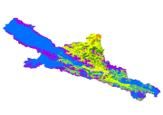
Vegetation map of upstream of the Heihe River V2.0

This data is a vegetation map of the upper reaches of Yingluoxia in the main stream of Heihe River, with a scale of 1:100,000 and an area of about 10,000 square kilometers. The data format is GIS vector format, which meets the data input requirements of eco-hydrological model. Map modification is still needed before publication. This version is version 2.0, and it is to be modified after compared with the survey data of the upstream sample belts of Heihe Project. Based on the "1:1 million Chinese Vegetation Map", the altitude, aspect and other terrains of the upper reaches of the Heihe River (based on ASTER GDEM) are analyzed in detail, combined with field survey data, literature, TM, ETM+ images, and Google Earth, etc., and with the optimization of the group boundary of "1:1 million Chinese Vegetation Map", this data is obtained. This data adjusts the type boundary of the 1:1 million vegetation map to a large extent, and is much more consistent with the altitude and aspect. This data can be directly used and edited in Arc GIS and its compatible software.
Data Citations
Cite as:Zheng, Y. (2015). < b>Vegetation map of upstream of the Heihe River V2.0</b>2015. doi: 10.3972/heihe.426.2014.db. (Download the reference: RIS | Bibtex )
Using this data, the data citation is required to be referenced and the related literatures are suggested to be cited.
Terms of Use
To respect the intellectual property rights, protect the rights of data authors, expand services of the data center, and evaluate the application potential of data, data users should clearly indicate the source of the data and the author of the data in the research results generated by using the data (including published papers, articles, data products, and unpublished research reports, data products and other results). For re-posting (second or multiple releases) data, the author must also indicate the source of the original data.
Related Resources
2.The leaf water potential dataset in the downstream of the Heihe River Basin (2012)
3.Grassland interception dataset of Tianlaochi watershed in Qilian Mountain
5.Leaf area index of Qinhai spruce stand at 2800 m above sea level in Pailougou watershed (2011)
9.Data of SPAC system in the lower reaches of Heihe River (2012-2013)
No record
No record
Comments
Sign In to add comments
Keywords
Geographic coverage
| Spatial coverage |
East:101.2 South:37.7 |
West:98.6 North:39.1 |
|---|
Details
- Format: SHP
- File size: 14.5 MB
- Browse count:9385
- Temporal coverage:2018-11-19 To 2018-11-19
- Access: Offline
- Updated time:2021-04-19
Authors
Resource Provider: ZHENG Yuanrun
Originator: ZHOU Jihua

 Copyright ©right; 2017 - 中国科学院西北生态环境资源研究院 - 兰州数云软件科技有限公司提供技术支持