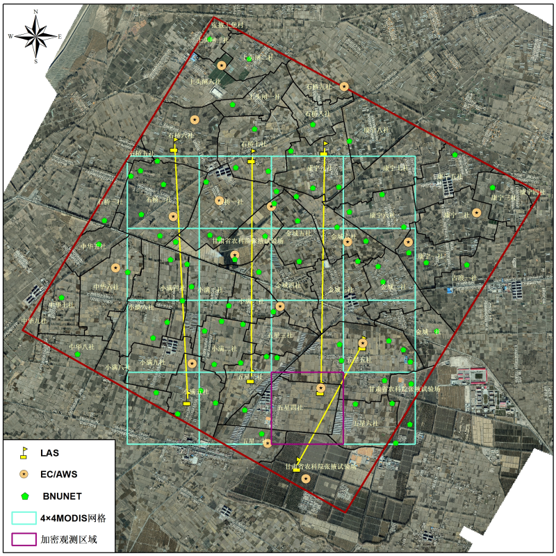
HiWATER: BNUNET soil moisture and LST observation dataset in the midstream of the Heihe River Basin (2012)

This dataset includes soil moisture and soil temperature observations of 75 BNUNET nodes during the period from May to September 2012 (UTC+8), which is one type of WSN nodes in the Heihe eco-hydrological wireless sensor network (WSN). The BNUNET located in the observation matrix of the HiWATER artificial oasis eco-hydrology experimental area. Each BNUNET node observes the soil temperature at 4 cm, 10 cm and 20 cm depth, and soil moisture at 4 cm depth with 10 minutes interval. This dataset can be used in the estimation of surface hydrothermal variables and their validation, eco-hydrological research, irrigation management and so on.
The detail description please refers to "Data introduction.docx".
Data Citations
Related Literatures:1. Rui Jin, Xin Li, Baoping Yan, Xiuhong Li, Wanmin Luo, Minguo Ma, Jianwen Guo, Jian Kang, Zhongli Zhu. 2014. A Nested Eco-hydrological Wireless Sensor Network for Capturing Surface Heterogeneity in the Middle-reach of Heihe River Basin, China. IEEE Geoscience and Remote Sensing Letters, 11(11): 2015-2019, DOI:10.1109/LGRS.2014.2319085(View Details |Download )
2. Li, X., Liu, S.M., Xiao, Q., Ma, M.G., Jin, R., Che, T., Wang, W.Z., Hu, X.L., Xu, Z.W., Wen, J.G., Wang, L.X. (2017). A multiscale dataset for understanding complex eco-hydrological processes in a heterogeneous oasis system. Scientific Data, 4, 170083. doi:10.1038/sdata.2017.83.(View Details |Download )
Cite as:Liu, J., Ma, M. (2016). < b>HiWATER: BNUNET soil moisture and LST observation dataset in the midstream of the Heihe River Basin (2012)</b>2016. doi: 10.3972/hiwater.119.2013.db. (Download the reference: RIS | Bibtex )
Using this data, the data citation is required to be referenced and the related literatures are suggested to be cited.
References literature
1.Li X, Liu SM, Ma MG, Xiao Q, Liu QH, Jin R, Che T, Wang WZ, Q R, Li HY, Zhu GF, Guo JW, Ran RH, Wen JG, Wang SG. HiWATER: An Integrated Remote Sensing Experiment on Hydrological and Ecological Processes in the Heihe River Basin. Advances in Earth Science, 2012, 27(5): 481-498. (View Details |Download)
2.Li Xin, Liu Shaomin, Ma Mingguo, Xiao Qing, Liu Qinhuo, Jin Rui, Che Tao. HiWATER: An Integrated Remote Sensing Experiment on Hydrological and Ecological Processes in the Heihe River Basin. Advances in Earth Science, 2012, 27(5): 481-498. (View Details |Download)
3.Li X, Cheng GD, Liu SM, Xiao Q, Ma MG, Jin R, Che T, Liu QH, Wang WZ, Qi Y, Wen JG, Li HY, Zhu GF, Guo JW, Ran YH, Wang SG, Zhu ZL, Zhou J, Hu XL, Xu ZW. Heihe Watershed Allied Telemetry Experimental Research (HiWATER): Scientific objectives and experimental design. Bulletin of the American Meteorological Society, 2013, 94(8): 1145-1160, 10.1175/BAMS-D-12-00154.1. (View Details )
Terms of Use
To respect the intellectual property rights, protect the rights of data authors, expand services of the data center, and evaluate the application potential of data, data users should clearly indicate the source of the data and the author of the data in the research results generated by using the data (including published papers, articles, data products, and unpublished research reports, data products and other results). For re-posting (second or multiple releases) data, the author must also indicate the source of the original data.
Support Program
Heihe Watershed Allied Telemetry Experimental Research (HiWATER)
Related Resources
1.The leaf water potential dataset in the downstream of the Heihe River Basin (2012)
2.HiWATER: the albedo in the middle reaches of the Heihe River Basin (Jun. 29, 2012)
3.HiWATER: Dataset of infrared temperature in Zhanye Airport desert
7.HiWATER: Airborne CCD image data in Hulugou Catchment
10.The soil heat flux dataset in the lower reaches of Heihe River (2011-2013)
No record
No record
Comments
Sign In to add comments
Keywords
Geographic coverage
| Spatial coverage |
East:100.398095 South:38.849118 |
West:100.333928 North:38.89629 |
|---|
Details
- Format: 文本
- File size: 156.0 MB
- Browse count:23326
- Temporal coverage:2012-06-03 To 2012-10-08
- Access: Offline
- Updated time:2021-04-20
Authors
Data Service: ZHAO Shaojie
Principal Investigator: KOU Xiaokang
Resource Provider: Liu Jun MA Mingguo

 Copyright ©right; 2017 - 中国科学院西北生态环境资源研究院 - 兰州数云软件科技有限公司提供技术支持