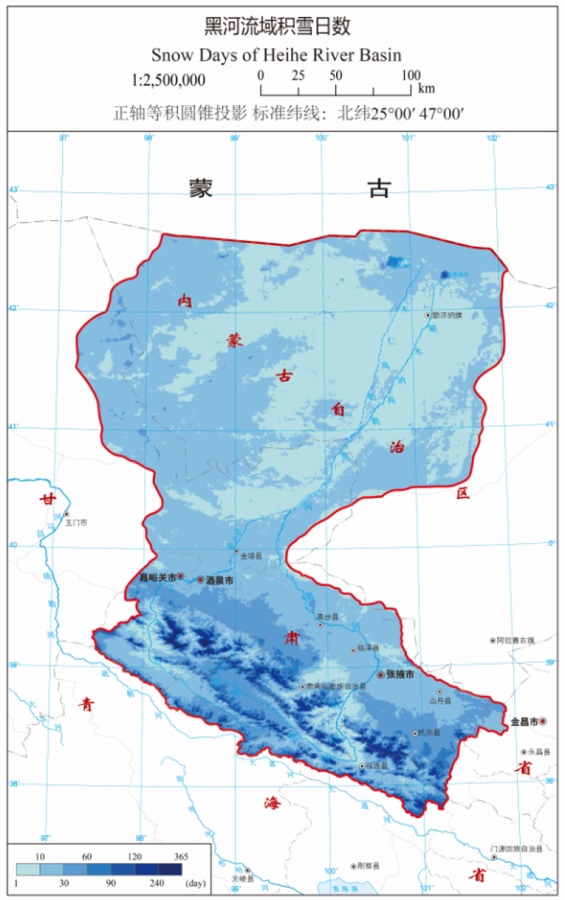
Snow Cover Days

"Heihe River Basin Ecological hydrological comprehensive atlas" is supported by the key project of Heihe River Basin Ecological hydrological process integration research. It aims at data arrangement and service of Heihe River Basin Ecological hydrological process integration research. The atlas will provide researchers with a comprehensive and detailed background introduction and basic data set of Heihe River Basin.
The snow day map of Heihe River Basin is one of the hydrological and water resources in the atlas, with the scale of 1:2500000, the positive axis and equal volume conic projection, and the standard latitude of 25 47 n.
Data source: this map shows the distribution of annual average snow days in 10 hydrological years in the whole Heihe River Basin from August 1, 2001 to July 31, 2011. The original data comes from MODIS daily snow products modisa 1 and myd10a1 provided by the National Snow and Ice Data Center (NSIDC) of the United States, as well as the long-term series snow depth data set of China provided by the scientific data center for cold and dry regions (WESTDC).
Copyright & License
. JPG format storage
Data Citations
Cite as:Wang, J., Zhao, J., Wang, X. (2015). < b>Snow Cover Days</b>2015. doi: 10.3972/heihe.0065.2013.db. (Download the reference: RIS | Bibtex )
Using this data, the data citation is required to be referenced and the related literatures are suggested to be cited.
Terms of Use
To respect the intellectual property rights, protect the rights of data authors, expand services of the data center, and evaluate the application potential of data, data users should clearly indicate the source of the data and the author of the data in the research results generated by using the data (including published papers, articles, data products, and unpublished research reports, data products and other results). For re-posting (second or multiple releases) data, the author must also indicate the source of the original data.
Related Resources
2.The leaf water potential dataset in the downstream of the Heihe River Basin (2012)
3.The boundary of Heihe River Basin (1985)
4.The soil heat flux dataset in the lower reaches of Heihe River (2011-2013)
6.The monitoring data of the groundwater level in the middle of Heihe River basin (2005-2007)
8.The boundary of the Heihe River Basin in 2010
No record
No record
Comments
Sign In to add comments
Keywords
Geographic coverage
| Spatial coverage |
East:104.2 South:37.7 |
West:96.1 North:43.3 |
|---|
Details
- Format: TIFF
- File size: 3.86 MB
- Browse count:10386
- Temporal coverage:2018-11-25 To 2018-11-25
- Access: Offline
- Updated time:2021-04-19
Authors
Resource Provider: WANG Jianhua ZHAO Jun WANG Xiaomin

 Copyright ©right; 2017 - 中国科学院西北生态环境资源研究院 - 兰州数云软件科技有限公司提供技术支持