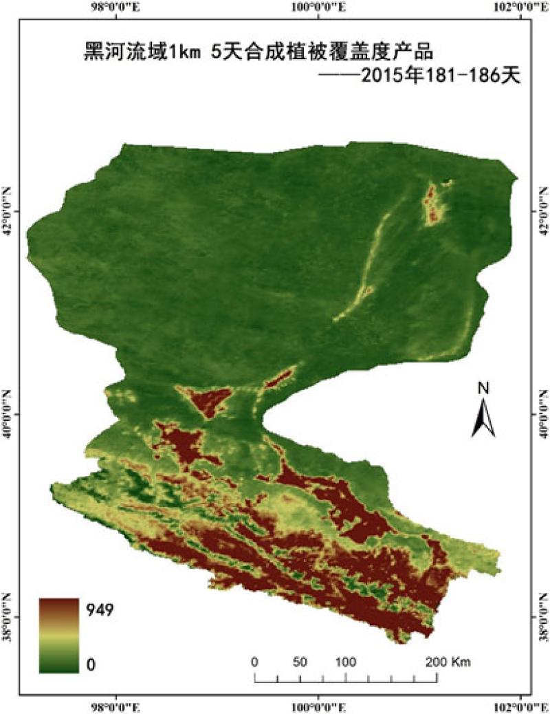
HiWATER: 1km/5day compositing Fraction Vegetation Cover (FVC) product of Heihe River Basin (2015)

The 1 km / 5-day FVC data set of Heihe River basin provides the 5-day FVC synthesis results in 2015. The data uses the data of Terra / MODIS, Aqua / MODIS, and domestic satellites fy3a / MERSI and fy3b / MERSI to build a multi-source remote sensing data set with a spatial resolution of 1 km and a time resolution of 5 days. The whole country is divided into different vegetation divisions and land types, and the conversion coefficient of NDVI and FVC is calculated respectively. The conversion coefficient look-up table and 1km / 5-day synthetic NDVI product production area 1km / 5-day synthetic FVC product are used. In the Heihe River Basin, 1 km / 5-day synthetic FVC products can directly obtain vegetation coverage ratio through high-resolution data to reduce the impact of low-resolution data heterogeneity; in addition, select the typical period of vegetation growth and change, obtain the corresponding growth curve parameters of each pixel by fitting the vegetation index of each pixel time series; and then cooperate with land use map and vegetation classification map, To find the representative uniform pixel of the region to train the conversion coefficient of vegetation index. Compared with the results of high-resolution aster reference FVC in Heihe River Basin, the first step is to aggregate the aster products in Heihe River basin to 1km scale by combining the measured ground data and using the scale up method, and to obtain the aster aggregate FVC data, which is based on spot vegetation remote sensing data released by geoland 2 project (geov1 for short) The results show that the results of geov1 are higher than those of ASTER image combined with ground measurement, and the results of 1 km / 5-day synthetic FVC products in Heihe River Basin are between the two, and the results of 1 km / 5-day synthetic FVC products in Heihe River Basin in the experimental area are better than those of geov1 products. In a word, the comprehensive utilization of multi-source remote sensing data to improve the estimation accuracy and time resolution of FVC parameter products can better serve the application of remote sensing data products.
Copyright & License
TIF format storage
Data Citations
Related Literatures:1. Xihan Mu, Yaokai Liu, Guangjian Yan, Yanjuan Yao, Fractional vegetation cover retrieval using multi-spatial resolution data and plant growth model, IEEE IGARSS’10 , Hawaii, USA, pp:241-244(View Details)
2. Li, X., Liu, S.M., Xiao, Q., Ma, M.G., Jin, R., Che, T., Wang, W.Z., Hu, X.L., Xu, Z.W., Wen, J.G., Wang, L.X. (2017). A multiscale dataset for understanding complex eco-hydrological processes in a heterogeneous oasis system. Scientific Data, 4, 170083. doi:10.1038/sdata.2017.83.(View Details |Download )
Cite as:Mu, X., Ruan, G., Zhong, B., Liu, Q. (2016). < b>HiWATER: 1km/5day compositing Fraction Vegetation Cover (FVC) product of Heihe River Basin (2015)</b>2016. doi: 10.3972/hiwater.337.2016.db. (Download the reference: RIS | Bibtex )
Using this data, the data citation is required to be referenced and the related literatures are suggested to be cited.
References literature
1.Li Xin, Liu Shaomin, Ma Mingguo, Xiao Qing, Liu Qinhuo, Jin Rui, Che Tao. HiWATER: An Integrated Remote Sensing Experiment on Hydrological and Ecological Processes in the Heihe River Basin. Advances in Earth Science, 2012, 27(5): 481-498. (View Details |Download)
2.Li X, Cheng GD, Liu SM, Xiao Q, Ma MG, Jin R, Che T, Liu QH, Wang WZ, Qi Y, Wen JG, Li HY, Zhu GF, Guo JW, Ran YH, Wang SG, Zhu ZL, Zhou J, Hu XL, Xu ZW. Heihe Watershed Allied Telemetry Experimental Research (HiWATER): Scientific objectives and experimental design. Bulletin of the American Meteorological Society, 2013, 94(8): 1145-1160, 10.1175/BAMS-D-12-00154.1. (View Details )
Terms of Use
To respect the intellectual property rights, protect the rights of data authors, expand services of the data center, and evaluate the application potential of data, data users should clearly indicate the source of the data and the author of the data in the research results generated by using the data (including published papers, articles, data products, and unpublished research reports, data products and other results). For re-posting (second or multiple releases) data, the author must also indicate the source of the original data.
Related Resources
2.HiWATER: the albedo in the middle reaches of the Heihe River Basin (Jun. 29, 2012)
4.HiWATER: Airborne CCD image data in Hulugou Catchment
8.HiWATER: Airborne CCD image data in the Shenshawo desert area of the Heihe River Basin
9.1:100000 topographic index of the Heihe River Basin
10.HiWATER: Airborne CCD image data in the middle reaches of the Heihe River Basin on July. 26, 2012
No record
No record
Comments
Sign In to add comments
Keywords
Geographic coverage
| Spatial coverage |
East:101.96 South:37.74 |
West:97.11 North:42.69 |
|---|
Details
- Format: ENVI标准格式
- File size: 33.6 MB
- Browse count:11506
- Temporal coverage:2015-01-10 To 2016-01-09
- Access: Offline
- Updated time:2021-04-19
Authors
Resource Provider: MU Xihan RUAN Gaiyan ZHONG Bo LIU Qinhuo

 Copyright ©right; 2017 - 中国科学院西北生态环境资源研究院 - 兰州数云软件科技有限公司提供技术支持