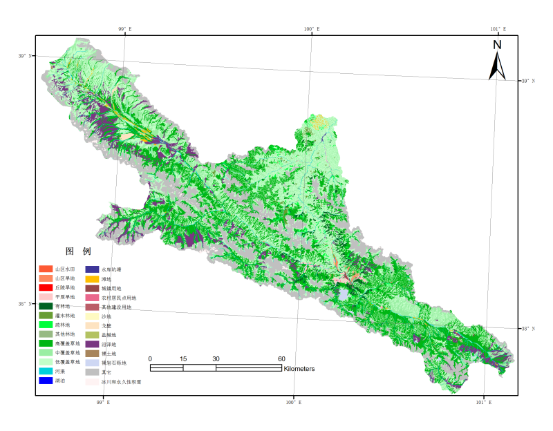
Land use / land cover data set for the upper reaches of the Heihe River Basin (2011)

The land use / land cover data set of Heihe River Basin in 2011 is the Remote Sensing Research Office of Institute of cold and drought of Chinese Academy of Sciences. Based on the remote sensing data of landsatm and ETM in 2011, combined with field investigation and verification, a 1:100000 land use / land cover image and vector database of Heihe River Basin is established.
The data set mainly includes 1:100000 land use graph data and attribute data in the upper reaches of Heihe River Basin. The land cover data of 1:100000 (2011) in Heihe River Basin and the previous land cover are classified into six first-class categories (cultivated land, forest land, grassland, water area, urban and rural residents, industrial and mining land and unused land) and 25 second-class categories by the same hierarchical land cover classification system. The data type is vector polygon and stored in shape format.
Copyright & License
. SHP format storage, can be read by ArcGIS
Data Citations
Cite as:Wang, J. (2014). < b>Land use / land cover data set for the upper reaches of the Heihe River Basin (2011)</b>2014. doi: 10.3972/heihe.107.2014.db. (Download the reference: RIS | Bibtex )
Using this data, the data citation is required to be referenced and the related literatures are suggested to be cited.
Terms of Use
To respect the intellectual property rights, protect the rights of data authors, expand services of the data center, and evaluate the application potential of data, data users should clearly indicate the source of the data and the author of the data in the research results generated by using the data (including published papers, articles, data products, and unpublished research reports, data products and other results). For re-posting (second or multiple releases) data, the author must also indicate the source of the original data.
Related Resources
1.Scenario analysis of social and economic development over Heihe River Basin (2020 & 2030)
2.A survey construction of a water-saving society in Zhangye city, Gansu (2013)
3.Leaf area index of Qinhai spruce stand at 2800 m above sea level in Pailougou watershed (2011)
5.Input output table of Heihe River Basin in Gansu Province in 2002 and 2007
6.Ground water level dataset in Hulugou sub-basin of Heihe River Basin (2011)
9.The data of desert plants photosynthetic organ traits (2011)
No record
No record
Comments
Sign In to add comments
Keywords
Geographic coverage
| Spatial coverage |
East:101.24 South:37.63 |
West:98.47 North:39.23 |
|---|
Details
- Format: shp
- File size: 186.0 MB
- Browse count:9032
- Temporal coverage:2018-11-24 To 2018-11-24
- Access: Offline
- Updated time:2021-04-19
Authors
Resource Provider: WANG Jianhua

 Copyright ©right; 2017 - 中国科学院西北生态环境资源研究院 - 兰州数云软件科技有限公司提供技术支持