HiWATER:Dataset of the chamber soil respiration in the middle of Heihe River Basin (2012)

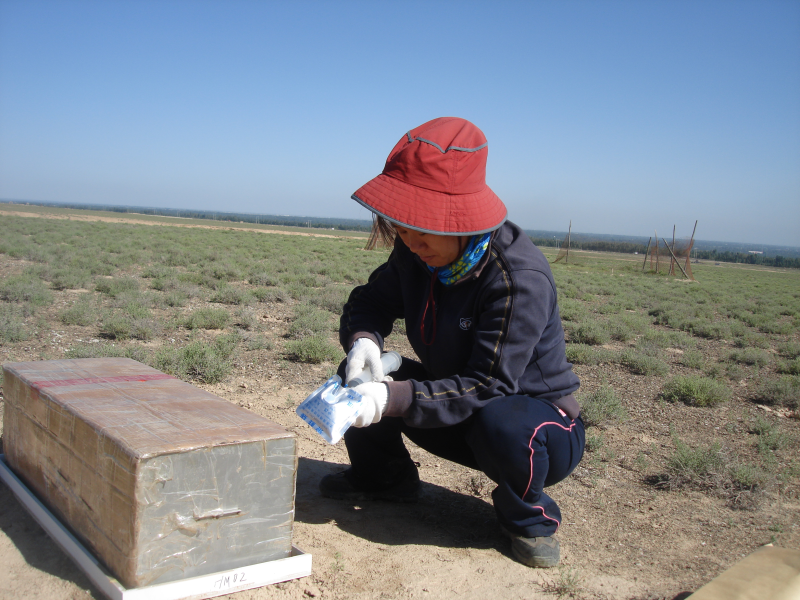
During the period of middle stream experiment in 2012, closed chamber and gas chromatography method was used to measure soil respiration of different land surface, including farmland, orchard, wetland, sparse grassland (Huazhaizi), Gobi, desert.
Instrument: Assimilation Chamber
Measuring method: Assimilation chamber consists of two parts: the base and the box. Base made of PVC material, the bottom buried in the soil. The box is made of stainless steel cubes, with one open side. When measuring the box cover on the base, air in the box was sampled using injector. The extracted air was injected into the gas sampling bag, and shipped back to the laboratory analysis of the concentration of CO2 by gas chromatography in Institute of Botany, The Chinese Academy of Sciences. Using the difference of concentration of CO2 at two times to calculate soil respiration. Each measurement points are located three repeat. After five minutes sealed box cover start mining the 1st sample, and then taken once every sample interval of 10 minutes, four times in total mining.
Date content: Data content includes header information and once every 10 days three times repeated observations and the average of the three times.
Measuring location: Gobi (Bajitan Gobi station), Wetland (Zhangye wetland Station), Sparse grassland (Huazhaizi desert steppe Station), Desert (Shenshawo sandy desert Station), Orchard (site No.17 eddy covariance system), Maize Farmland (Daman Superstation)
Measuring time: 16-6-2012, 28-6-2012, 9-7-2012, 18-7-2012, 30-7-2012, 11-8-2012, 21-8-2012, 2-9-2012, 13-9-2012, 22-9-2012 (UTC+8).
Data Citations
Related Literatures:1. Li, X., Liu, S.M., Xiao, Q., Ma, M.G., Jin, R., Che, T., Wang, W.Z., Hu, X.L., Xu, Z.W., Wen, J.G., Wang, L.X. (2017). A multiscale dataset for understanding complex eco-hydrological processes in a heterogeneous oasis system. Scientific Data, 4, 170083. doi:10.1038/sdata.2017.83.(View Details |Download )
Cite as:Ma, M. (2017). < b>HiWATER:Dataset of the chamber soil respiration in the middle of Heihe River Basin (2012)</b>2017. doi: 10.3972/hiwater.035.2013.db. (Download the reference: RIS | Bibtex )
Using this data, the data citation is required to be referenced and the related literatures are suggested to be cited.
References literature
1.Li Xin, Liu Shaomin, Ma Mingguo, Xiao Qing, Liu Qinhuo, Jin Rui, Che Tao. HiWATER: An Integrated Remote Sensing Experiment on Hydrological and Ecological Processes in the Heihe River Basin. Advances in Earth Science, 2012, 27(5): 481-498. (View Details |Download)
2.Li X, Cheng GD, Liu SM, Xiao Q, Ma MG, Jin R, Che T, Liu QH, Wang WZ, Qi Y, Wen JG, Li HY, Zhu GF, Guo JW, Ran YH, Wang SG, Zhu ZL, Zhou J, Hu XL, Xu ZW. Heihe Watershed Allied Telemetry Experimental Research (HiWATER): Scientific objectives and experimental design. Bulletin of the American Meteorological Society, 2013, 94(8): 1145-1160, 10.1175/BAMS-D-12-00154.1. (View Details )
Terms of Use
To respect the intellectual property rights, protect the rights of data authors, expand services of the data center, and evaluate the application potential of data, data users should clearly indicate the source of the data and the author of the data in the research results generated by using the data (including published papers, articles, data products, and unpublished research reports, data products and other results). For re-posting (second or multiple releases) data, the author must also indicate the source of the original data.
Support Program
Heihe Watershed Allied Telemetry Experimental Research (HiWATER)
Related Resources
1.The leaf water potential dataset in the downstream of the Heihe River Basin (2012)
2.HiWATER: the albedo in the middle reaches of the Heihe River Basin (Jun. 29, 2012)
3.HiWATER: Dataset of infrared temperature in Zhanye Airport desert
7.HiWATER: Airborne CCD image data in Hulugou Catchment
10.The soil heat flux dataset in the lower reaches of Heihe River (2011-2013)
No record
No record
Comments
Sign In to add comments
Keywords
- Discipline: 陆地表层
- Theme: 土壤 土壤呼吸
- Places:
- Time: 2012 2012-06-16 to 2012-09-22
Geographic coverage
| Spatial coverage |
East:100.4925 South:38.7652 |
West:100.3058 North:38.918 |
|---|
Details
- Format: 文本
- Browse count:13346
- Temporal coverage:2012-07-01 To 2012-10-07
- Access: Offline
- Updated time:2021-04-19
Authors
Principal Investigator: LI Xianglan
Resource Provider: MA Mingguo

 Copyright ©right; 2017 - 中国科学院西北生态环境资源研究院 - 兰州数云软件科技有限公司提供技术支持