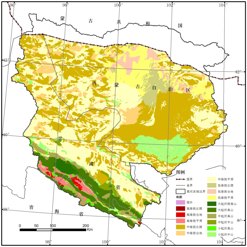
1:1,000,000 Geomrphological map of the Heihe River basin (2000)

The geomorphic data of Heihe River are from the geomorphic Atlas of the people's Republic of China (1:1 million). This data is based on remote sensing image and other multi-source data integration and update. The main data used and referenced include: 1) remote sensing image data: TM and 2000's around 1990's nationwide About ETM image; 2) historical geomorphic map: 15 published 1 million geomorphic maps, two sets of 1:4 million geomorphic maps in China, 500000 or 1 million geomorphic sketches in all provinces and cities in China; 3) basic geographic data: 1:250000 basic geographic data and 250000 DEM data in China; 4) geological data: 1:500000 geological map in China; 5) relevant thematic maps: land use map, vegetation map and land resource map And so on. The interpretation method adopts the human-computer interaction method based on ArcGIS, and is carried out according to the interpretation sequence of hierarchical classification: the first layer: plain and mountain; the second layer: basic geomorphic types (28); the third layer: 10 genetic types; the fourth layer: secondary genetic types; the fifth layer: morphological difference classification types; the sixth layer: secondary morphological difference classification types; the seventh layer: slope, slope The eighth layer is the type of geomorphic material determined by material composition or lithology; the ninth layer is the combination of 1-7 layers of map spots. There are 441 geomorphic types and codes. Data fields include: fenfu (view frame number), name (attribute), class (code), sname (administrative division).
Copyright & License
File name: the data is stored in vector SHP format with the file name "Heihe_Digital_Geomorphology. shp".</p><p>Data reading: Arcgis, Qgis and other software can be used to open the reading, Arcgis open, directly read the SHP file, to graphical expression.
Data Citations
Cite as:Cheng, W. (2013). < b>1:1,000,000 Geomrphological map of the Heihe River basin (2000)</b>2013. doi: 10.11888/Geogra.tpdc.270604. (Download the reference: RIS | Bibtex )
Using this data, the data citation is required to be referenced and the related literatures are suggested to be cited.
References literature
1.Chai H.X, Zhou C.H, Chen X, Cheng W.M, (2009). Digital regionalization of geomorphology in xinjiang. journal of geography, 19(5), 600-614. (View Details )
Terms of Use
To respect the intellectual property rights, protect the rights of data authors, expand services of the data center, and evaluate the application potential of data, data users should clearly indicate the source of the data and the author of the data in the research results generated by using the data (including published papers, articles, data products, and unpublished research reports, data products and other results). For re-posting (second or multiple releases) data, the author must also indicate the source of the original data.
Support Program
Related Resources
1.Physical and chemical index data of deep drilling strata in the middle reaches of Heihe River (2013)
2.Datasets for the SWAT model in Heihe Rriver Basin
5.1:1,000,000 Geomrphological map of the Heihe River basin (2000)
6.Landuse/landcover data of the Heihe River Basin in 2000
7.SRTM DEM data of the Heihe River Basin (2000)
No record
No record
Comments
Sign In to add comments
Keywords
Geographic coverage
| Spatial coverage |
East:104.2 South:37.7 |
West:96.1 North:43.3 |
|---|
Details
- Temporal resolution: Yearly
- Spatial resolution: 10m - 100m
- Format: shp
- File size: 35.09 MB
- Browse count:13772
- Temporal coverage:2000-01-11 To 2001-01-10
- Access: Offline
- Updated time:2021-04-19
Authors
Resource Provider: CHENG Weiming
Owner: ZHOU Chenghu

 Copyright ©right; 2017 - 中国科学院西北生态环境资源研究院 - 兰州数云软件科技有限公司提供技术支持